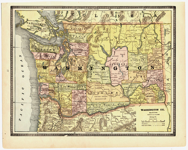
How Washington Territory looked in 1884
Did you ever hear of Chehalis County? Did you know that Ellensburg’s name once had an “h” at the end? Were you aware of a town called Ainsworth where Pasco now stands?
You can discover all of these little factoids by looking at this 1884 railroad map of Washington Territory, found in the State Library’s Digital Collections under Historical Maps.
The map reveals a handful of railroads snaking through just a few parts of Washington at the time. No east-west route had been built over the Cascades, although a route did go through the Columbia River Gorge. The main north-south railroad in Western Washington didn’t go north beyond Seattle. One reason was because Everett didn’t even exist. Several other well-known towns weren’t around in 1884: Bremerton, Federal Way, Shelton, Wenatchee, Moses Lake, and Richland and the rest of the Tri-Cities.
Looking closely at the map, you discover many interesting things about the counties five years before Washington attained statehood:
By far, the largest county in 1884 was Stevens, which included what is now Pend Oreille, Stevens, Ferry, Okanogan and most of Chelan counties.
- What is now Grays Harbor County was Chehalis County then.
- Benton County didn’t exist. Instead, Yakima and Klickitat counties extended east and encompassed the area that is now Benton.
- Grant County also wasn’t around in 1884. Douglas County included the area that later became Grant.
- Wahkiakum County stretched farther north into what is now the southwestern corner of Lewis County.
- Cowlitz County reached farther south into what is now Clark County. (it was called Clarke at that time.)
- Thurston County stretched farther east into what is now southern Pierce County.
- Instead of following the high ridges of the Cascades as they do today, the eastern borders of Whatcom, Skagit, Snohomish, King, Pierce and Lewis counties were much straighter.