A Snapshot of Asotin County

Asotin is second in a series covering Washington’s 39 counties, including how they got their names.
Nestled in the reaches of Washington’s far southeastern corner is Asotin County (pronounced uh-SOH-tin). It is colloquially referred to as Washington’s “cornerstone.” Asotin, a word derived from the Nez Perce Indian language (originally Has-Hu-Tin), translates into English as, “eel creek.” This title refers to the eels that are ubiquitous in the waterways in and around Asotin County, including the Snake River.
Before the arrival of the pioneers, Asotin County was home to a large Nez Perce winter encampment. The climate of Southeastern Washington was amenable for the Nez Perce, and they held large pow-wows on the banks of the Snake. There was always plentiful food available from both the rivers and hunting.
Asotin County is geographically small compared to some of Washington’s other counties, encompassing only 636 square miles. This designates it as 35th in size out of Washington’s 39 counties. As for population, Asotin has about 22,000 residents, which gives the county a rural feel. For some perspective, the population density of Asotin County is 34 people per square mile, compared the state average of 101 people per square mile.
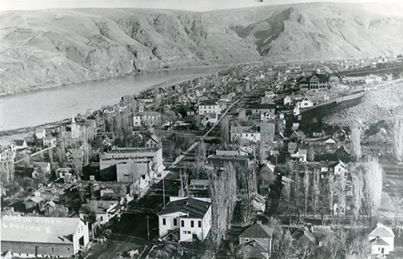
Asotin County has two main cities within its borders, Asotin, which is the county seat, and Clarkston, its largest city.