


WSL Special Collections holds evidence in a mapping mystery!
 From the desk of Sean Lanksbury. PNW & Special Collections Librarian
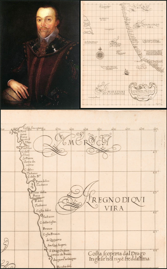
Well, perhaps that title is a touch dramatic, but we are very pleased to share with you a very interesting item with importance to northwest cartographic history. The mystery starts with a gentleman named Sir Francis Drake. Perhaps you have heard of him. If not, then you should know that Sir Francis was the second seafarer to circumnavigate the earth, from 1577 to 1580, second only to Ferdinand Magellan, and the first to return with his ship (Magellan was killed en route).
According to the historical record, Drake made port on the north pacific shoreline June 17 1579, north of the Spanish claimed Point Loma (now part of San Diego, CA) after an eventful trip around the horn of South America and raiding for gold on Spanish Ships in Lima. Herein lies the mystery—how far north of San Diego did Drake travel and where did he and his crew touch ground? Did he make port in Bolinas, in San Francisco, California? Nehalem Bay, Oregon? Or did he travel as far as Washington or even Alaska?! The exact point where he stopped was kept secret for reasons of British national security. They remain secret as all of Drake’s primary documents from his voyage likely burned up in the Whitehall Palace Fire of 1698.
So how does this all possibly connect to the map shown above? Well, this map, Carta particolare dello stretto di Iezo: fra l’America è l’Isola Iezo. D’America carte XXXIII, is the first Mercator projection of the Northwest coastline and one of the first serious maps of the region. It was produced in Florence, Italy by noted English explorer Sir Robert Dudley as part of his cartographic masterwork, Dell Arcano del Mare, this particular map is also notable for its depiction of shoreline features above a longitude of 39°N, Cape Mendocino, all the way to the 50th parallel, the northern tip of Vancouver Island. You might see some similarities to the modern coastline of Washington and Oregon, especially features that resemble the Columbia River and the Strait of Juan de Fuca. Then again, you might not, but many others do, and some researchers suspect that Sir Dudley, who never actually visited the Pacific coastline, may have based his engravings off some insider knowledge. Robert was the illegitimate son of another Sir Robert Dudley, First Earl of Leicester, and this Robert was a main financier of Francis Drake’s Famous Voyage. So, did the son have access to Drake’s secreted charts through his family connection to the expedition? Is the chart pure speculation above Mendocino? It is a matter for debate, and historians both professional and amateur have been going toe-to-toe on the subject for centuries.
This map is available for use (by appointment) at the Special Collections Desk , M-F 8:00 a.m. – 4:30 p.m.
Interested in learning more about maps of Washington or theories surrounding Francis Drake? Try out these titles available at the Washington State Library:
-
The Cartography of the Northwest Coast of America to the Year 1800.
By Henry R. Wagner. (Mansfield Centre, CT: Martino Pub., 1937
[Limited ed. facsimile of the original ed. produced in 1999] OCLC / WSL
-
Historical atlas of the Pacific Northwest: Maps of Exploration and Discovery:
British Columbia, Washington, Oregon, Alaska, Yukon. By Derek Hayes.
(Seattle : Sasquatch Books, 1999. 208 pp.) OCLC / WSL
-
The Golden Hind. By T. W. E. Roche.
(New York: Praeger, 1973. 200 pp.) OCLC / WSL
-
Francis Drake in Nehalem Bay in 1579: Setting the Historical Record Straight.
By Garry David Gitzen. (Wheeler, Or.: Isnik Pub., 2008. 245 pp.) OCLC / WSL
You can follow any responses to this entry through the RSS 2.0 feed. Both comments and pings are currently closed.
September 21st, 2012 at 10:05 am
So, how did the State Library acquire this particular map? Is it a standalone map, or is it published in a book or collection of maps? Just curious . . .
September 21st, 2012 at 2:01 pm
Hi, Will:
The map was acquired a few years ago as a single map sheet. Originally this map was part of the larger cartographic work, Dell’ Arcano del Mare, which encompasses the entire world as known in 1649. It has been orphaned from that work, which is, sadly, quite common for maps originally bound in atlases and other published works. Thanks for asking.