Hey, I don’t see Benton County on this map!
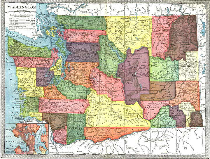
1904 Washington map. (Image courtesy of Legacy Washington)
Anyone who is really into Washington geography knows that our state has 39 counties. But did you know that hasn’t always been the case?
There was a time when a few of today’s counties weren’t even around at the turn of the 20th century. This 1904 map of Washington offers visual proof.
What is now Benton County was part of Yakima and Klickitat counties. Douglas County was A LOT larger in 1904 because it included what is now Grant County. And Pend Oreille County? Part of Stevens County at that time.
If you carefully look at the 1904 map, you’ll discover a few well-known cities literally weren’t on the map. No Bellingham (it was called Whatcom). No Mukilteo. And no Federal Way.
This historic map was made by The Americana Company and published by Bormay and Company of New York.
Our State Archives and State Library hold extensive map collections dealing with our state and the surrounding region. You can see find many other historic maps of Washington by going to Legacy Washington‘s historical map collection here.
3 thoughts on “Hey, I don’t see Benton County on this map!”
No Grays Harbor County either
Yes, you are correct! It was called Chehalis County back then, although its borders are the same as Grays Harbor County’s borders now.
No Pend Oreille Co. and part of Ferry Co. was moved over to Stevens Co.. Reading the old Road Commissioners journals at Whitman County I read that Franklin and Adams Counties were part of Whitman County at one time… must have been prior to 1904.
Comments are closed.