Check out 1950 Washington highway map
Most Washingtonians probably can’t even remember life before Interstate 5, I-90 and I-405 were built in our state.
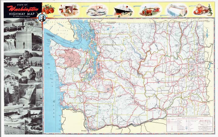
But a 1950 state highway map found on our Legacy Washington webpage shows the routes drivers traveled before the arrival of our interstate freeways.
- You can make some interesting observations by closely examining the map, which was published by the Washington State Highway Commission:
- The main north-south highway in Western Washington was U.S. 99, which connected Bellingham, Everett, Seattle, Tacoma, Olympia and Vancouver just as I-5 does today.
- U.S. 10 was the east-west precursor to I-90, running through the same communities, including North Bend, Ellensburg, Moses Lake and Spokane.
- State Route 410, which today winds east from Sumner and over Chinook Pass before ending just west of Naches, was known back then as U.S. 410 and stretched from Aberdeen across Eastern Washington to Idaho, running through Yakima, the Tri-Cities, Walla Walla and Clarkston. The segment between Naches and Clarkston is now part of U.S. 12.
- State Route 18, a heavily used shortcut from I-5 to I-90 that travels through Auburn and Maple Valley, wasn’t around then.
- Many of our current state highways had different numbers back then: Highway 6 in Southwest Washington was Highway 12. Highway 14 along the Columbia River Gorge was Highway 8 and U.S. 830. Highway 26, which so many WSU students and grads know as the “Road to Pullman,” was preceded by Highway 11-B between Colfax and Washtucna, but the part of Highway 26 that now extends from Washtucna to Othello and the Columbia River had yet to be built.
You can view more historical maps of Washington and the Northwest by going here.