Library jewel #2: History of NW roads, pioneer trails
(Image courtesy of Washington State Library)
We’re all familiar with Washington’s network of freeways and highways. But not many of us know about the early days of roads or pioneer trails in Washington and the Pacific Northwest.
Thanks to the efforts of one couple in the 1960s, the State Library possesses a vast collection of information and photos about those early roads and pioneer trails. George and Annie Drew researched the history of Washington State. Their research turned into a series of 21 notebooks that covered different aspects of that history. The Drews’ collection is our second Library jewel for September. These notebooks are one set of three that were researched and assembled by this very busy couple. A set of 15 notebooks on the history of Seattle and King County and another five-book set on Washington State history also can be found at the State Library.
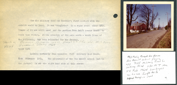
When the Drews did their research on roads and trails, they took Eastman Kodacolor photographs of the current location of the historical place they were researching. The 21 notebooks contain approximately 1,228 photographs. The majority of the photographs are color and includes some color postcards in the notebooks. (One of them, featured above, has a comment about I-5 following much of the Old Millitary Road, which followed much of an old Native trade route.) There are a few maps interspersed within the notebooks. The collection includes the first notebook compiled by the Drews, which focuses on the roads that would become Interstate 5 and I-90.
The collection includes research on Mullan’s Military Road eastbound from Old Fort Walla Walla to Palouse Falls; Palouse Falls to Cataldo, Idaho; glossary of geographic features of Washington and Idaho; Colville Military Road; Joseph (Chief Joseph and the Nez Perce); Military Road northbound from Longview to Chehalis; Claquato to Conway; mud-wagons to freeways; Ship Canal Bridge; Old Pacific Highway; buildings removed for I-5 construction; Interstate 5, interchanges, military roads, Interstate 90, I-90 floating bridge, state routes, and miscellaneous notes on Washington Territory and Washington State transportation history.
The third and final Library jewel will be unveiled later this week. Afterward, check out the online poll featuring all of this month’s jewels.
