State Library Jewel #1: 1924 WA road map
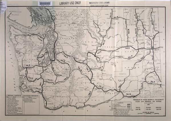
(Map courtesy of Washington State Library)
We recently finished showcasing three special items housed in our State Archives. Now, it’s the State Library’s turn.
Starting this week, we’ll do a monthly feature on three of the many rare, unique or interesting items, maps and collections found in the State Library. After we show them off, you and others can vote in our online poll by choosing the State Library “contestant” you like best. After a few days, we’ll announce the January winner.
The first contestant is this 1924 road map from the State Highway Department. It shows the primary and secondary state highways that were to be completed by 1936. The map indicates there were 1,710 paved miles of highway in Washington, and another 1,400 miles that were gravel. Not a good time to be a windshield!
Long before Interstate 5 was built, the main north-south highway from Bellingham south to Vancouver was Highway 99. On this map, it’s Highway “No. 1.” And yes, there is such a place called “Forest” a few miles south of Chehalis.
This map shows that Highway “No. 2” made it possible to drive from Seattle to Spokane long before I-90 was built. Note that No. 2 generally follows a route from Seattle to Cle Elum that’s similar to where I-90 snakes along today. But then No. 2 heads north toward Leavenworth, providing a precursor to where highways 970 and 97 travel today. From the Leavenworth area, No. 2 basically follows the same path as U.S. Highway 2 currently takes to reach Spokane, except that portions of it are no longer gravel, as it was back then.
(We originally ran the blog series in 2012. Due to its popularity, we’re bringing it back for an encore performance!)