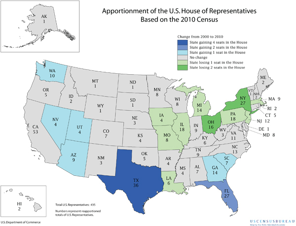
A perfect 10! WA awarded new congressional seat
Map courtesy of U.S. Census Bureau
Celebration time! Washington’s population grew by over 14 percent in the past decade and will gain a new congressional seat.
Washington’s former governor, Gary Locke, now President Obama’s commerce secretary, presided over a nationally televised press conference to release the 23rd Census since the founding of the republic.
Relative to the rest of the nation, Washington grew enough in the past 10 years to nab a 10th congressional district. Our latest population number: 6,724,540 million people. The population growth in the West also was very strong, up 13.8 percent, with the region passing by the Midwest in terms of population. The U.S. average growth was 9.7 percent, and we’re now 308.7 million people. Census officials said 60 percent of the growth nationally was new babies and 40 percent was due to immigration.
As had been projected from preliminary estimates, Washington will gain a 10th district starting with the 2012 elections, most likely to be added in the rapidly growing greater Puget Sound region. All of the current districts will be changed significantly.
The idea population will be 672,454 people per congressional district; the ideal new legislative district will be 137,235.
Election officials at the state Capitol watched the Census news conference and erupted in cheers as the map flashed on the screen showing that Washington is one of a handful of states to pick up one or more seats. Several states also lost one or more seats.
Secretary of State Sam Reed said he was delighted with the news of a new seat:
“We couldn’t be happier. This is a great day for the people of Washington. We gain in clout, with another strong voice in Congress to be added in 2012. We gain an Electoral College vote and our population gain means we get a little larger slice of the pie as federal grants are apportioned out based on population.”
The actual work of divvying up the state in equal-sized congressional districts and legislative districts will be the task of a bipartisan citizen commission. Four voting citizen members – two Republicans and two Democrats – will be appointed by the legislative caucus leaders, and the four will choose a fifth, nonvoting, person to be chairman. The panel will have all of 2011 to develop and finalize the maps, and three of the four voting members must vote for the final product. The Legislature has virtually no role and the governor cannot sign or veto the maps.
The new districts will be used in 2012, both for the primary in August and the general in November.
For some great background, our Redistricting webpage with background: http://bit.ly/9Zk20q .
Here’s a primer and a new historical booklet, 14 pages, of how the congressional districts developed since statehood, and who represented each.
We got our 8th District after the 1980 Census and our 9th after the 1990 Census.
Postscript: Here are the other states that picked up one or more seats: Texas (4), Florida (2), and Arizona, Georgia, Nevada, South Carolina and Utah, all one. Of those losing: New York (2), Ohio (2), and Illinois, Iowa, Louisiana, Massachusetts, Michigan, Missouri, New Jersey and Pennsylvania, all losing one.
