Shifting boundaries: Redistricting afoot
 The politically sensitive issue of how to re-draw Washington’s congressional and legislative boundaries will be turned over to an independent citizen commission after the 2010 Census — but work is already under way. The Secretary of State’s redistricting office — a grand name for two staffers! — has just launched a terrific new website that spells it all out.
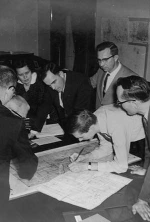
This political art-and-science, much beloved by government and election techno-geeks, is called “redistricting.” Every 10 years, the Constitution requires that our districts be redrawn so they’re of basically equal population — nine U.S. House districts and 49 legislative districts. (This photo, provided by Howard E. McCurdy, shows Gov. Dan Evans and others reviewing a redistricting map in the 1960s.)
Over the course of a decade, population shifts greatly in some parts of the state. For instance, the 8th and 3rd congressional districts have surged in population and will be shedding some of their voters in the next round of redistricting. Some of our legislative districts, such as in Southwest Washington’s 17th and 18th, and King County’s 5th and the 2nd in King, Pierce and Thurston, are way too big.
The new website describes how a voter-approved, bipartisan commission will do the actual work. Short version: The four legislative caucuses each names a citizen commissioner and the four appoint a non-voting member as chair, such as a law prof or geographer/demographer. Neither side can “jam” the other, since the maps must be approved by at least three of the four voting members. The governor gets no vote and the Legislature must accept the plan up-or-down, with very little room for moving any of the lines.
The system, which has gotten high marks so far, was adopted by the Legislature and the voters back in 1983. Before that, it was pretty ugly sometimes, with self-interested legislators getting tied up in knots. Voters or the courts were sometimes required to make the decision.
The Secretary of State’s redistricting office — David Valiant and Nick Pharris — has been doing spade work since October of 2007, providing detailed maps and data to the U.S. Census folks. They’ll also research how each precinct voted in the elections since 2004. The project will be turned over to the Legislature next July and then to the Commission in January of 2011. New districts will be used for the 2012 elections and thereafter.
Footnote: The new site has an overview, FAQs, great history (including old maps and photos), and even a cool do-it-yourself board game created by the Washington State Historical Society.