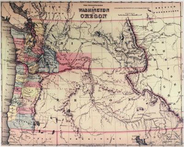
From the Archives: 1853 map of WA & OR territories
(Image courtesy of Washington State Digital Archives)
Most of us are familiar with the geographical shape of our great state of Washington, and some even know how Oregon looks. But do you know how Washington and Oregon appeared when both were young territories?
The Washington State Digital Archives has an 1853 map of both territories, months just after Washington split off from its southern neighbor and became its own territory. You’ll see that Washington Territory back then included what is now northern Idaho.
The map shows counties, rivers, mountain ranges and other marked features. It’s interesting to realize that the cities of Tacoma, Everett, Bellevue, Bremerton, Yakima, Richland, Spokane and several others literally were not on the map yet!
You’ll see that most of the counties in both territories were located on the west side of the Cascades. Back then, Skamania (which stretched east and north into present-day Kittitas, Yakima and Klickitat counties) and Walla Walla counties were the only WA counties east of the mountains. (Walla Walla back then also covered a much greater area than today, including what are now Benton, Franklin, Whitman, Garfield, Columbia and Asotin counties.)
This is only one of many historic maps kept online in the Digital Archives’ General Map Collection, 1851-2005. The digital collection features more than 2,000 maps, including U.S. Geological Survey maps, railroad maps, highway maps, maps of rivers and tidelands, charts, county and city maps, forest area maps, park maps and more.