


Happy Geologic Map Day!
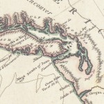
From Capt. Cook’s charts, 1808
Maps!
- Maps are Art!
- Maps are Information!
- Maps are Science!
- Maps are Math!
- Maps are History!
Maps are all these things and more – they explore and illustrate the geology of an area, the political boundaries we establish (and then fight over), the topography of mountains, and the territories claimed by Native Americans.
 Oct. 17 is Geologic Map Day (woot!). To celebrate, the Washington State Department of Natural Resource’s Geology and Earth Resources Division, in cooperation with the Oregon Department of Geology and Mineral Industries, has produced a map to highlight the geologic influences that converge along the Columbia River. The map poster is available for download as a 34-by-44-inch PDF or as eight 11-by-17-inch PDFs for easy assembly.
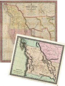
But wait – there’s more! The State Library’s online collection of Historical Maps offers maps recording discoveries from Captain Cook’s voyages published in 1808, early maps of Washington and Oregon Territories, city and county maps, railroad maps, coastal survey maps, maps from military campaigns, and maps from an 1809 German atlas. Here is a small sampling of the maps available (files are available in two formats: DJVU (requires plug-in), and JPG):
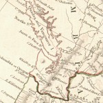
British N. America (1834)
- Chart of the N.W. coast of America… (1808)
- New map of Texas, Oregon and California… (1846)
- City of Spokane (1906)
- Map of Lincoln County Washington (1919)
- Map of the Chicago & North-Western Railway (1898)
- Map of military road from Fort Walla Walla (1863)
- Plan of the Battle of the Four Lakes, Sept. 1st, 1858
- Handatlas uber alle bekannte Laender… 1809
We hope you’ll take some time to explore the digital map collection and see Washington through the ages in a whole new light.
You can follow any responses to this entry through the RSS 2.0 feed. Both comments and pings are currently closed.